Trebula Balliensis
Why did the ancient Trebula rise?
The samnite town Trebula rose as defence centre to control the pass linking the Campania's plain with the Alife's plain. This link was possible going through Pontelatone, Treglia, Liberi, Maiorano di Monte, as far as Dragoni's plain. Moreover, the growth of Trebula was due to its strategic position: in fact Trebula rose in an area very important for the links among South Latium, Campania and Samnium. Some arms and various objects discovered in the average Volturno valley allowed to ascertain the existence of cultural and trade contacts among the zone of Trebula, Cales (Calvi Risorta), Teanum Sidicinum (Teano) and Rufrae (Presenzano). The strategic aim of samnite Trebula is obvious if we observe the stately town-walls and the acropolis of Monticelli hill (477 m) that dominates the tableland, named "La Corte", where was the ancient town. But was always such as we know it today the topographic look of ancient Trebula? That is, was always on the "La Corte" tableland the built-up area of Trebula? To reply this question we need to observe what follows: several samnite tombs have been discovered at feet of "Monticelli" hill and inside the surrounding wall. Now the Trebulani (the inhabitants of Trebula), as all Samnites, buried the dead out of the surrounding walls; this means at first the built-up area wasn't in the tableland but just on the acropolis of the Monticelli hill. Most likely at first Trebula rose as simple fortification to control its pass. Subsequently, because of demographic increase and persistent threats of the Romans the built-up area shifted to the tableland. In this way, it was necessary to build the surrounding wall that delimits it.
The management
Trebula remained indipendent all through the time of samnite wars; after the victory over Pirro (272 B.C.) the towns of the Caudini's district (Trebula was a member of this district) were compelled to make separated treaties with Rome. This means Trebula became a "civitas foederata", that is a town allied with Rome but nominally indipendent. The Tito Livio's news "Arpinatibus Trebulanisque civitas data" about the citizenship awarded from Romans to Trebulani no doubt refers to Trebula Suffenas (Ciciliano near Tivoli) (See Solin). During the second punic war Trebula, with other italic towns, deserted from Rome allying with Hannibal but it was reconquered by Fabio Massimo that, in 215 B.C., conquered it with Cubulteria (present day Alvignano) and Austicula. In fact, Cubulteria and Austicula deserted from Rome too (Livio, XXIII, 39). After the second punic war Trebula remained a "civitas foederata" until the social war owing to that Rome awarded the citizenship to all italics. At that very time Trebula rose a municipium governed by "quattuorviri iuri dicundo" . In fact, this kind of the politic management was the typical magistracy of the municipia born from ex allied towns. At late imperial age Trebula was governed by "duoviri" but we don't know the reasons of this change.
The infrastructure of Trebula
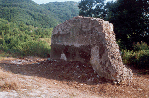
It is not easy to establish when grew the roman town, but it is probable that was put into effect a rational urbanistic project owing to establishment of the municipium. But we can recognize different infrastructures. The square (forum) was at centre-east area of the tableland "La Corte" that borders the main road Treglia-Liberi (See Fig.1). Instead the theatre was bringed out during the excavation done at Treglia at the end of 1800 by Domenico Carafa that was the prince Michele Carafa's son. It is South-East oriented (See fig.1) and it is probable that it looked on one of the streets of the town. We can imagine an hypothetical street linking the forum with the west gate. The cavea, that is the area bound to public and made up of semicircular tiers, is about 30 metres in diameter. The theatre has been dated from the beginning of the 2nd century A.D. but we can't obtain a straight checking because it is covered with earth. In front of the forum, along the carriageway linking Treglia with Campole locality, there are the thermae (Fig. 1) that did to Trebula the "Balliensis" appellative. Plinius refers to it in his work Naturalis Historia (3,64). The aqueduct arised from the springs that are at slopes of Mount Friento. It fed the thermae and the remainder of Trebula. Nowadays the two named springs are still existing and are not very far away one the other. One was named Chorsicon (Corcica) and the other Chersicon (Ciesco). The aqueduct had its entry point into the town a little south of the Tora bridge. Here are still visible the remains of the castellum aquae , that is the water reservoir (See photo A).

Fig. 1: The archaeological map of Trebula Balliensis. In red the town walls, in blue RioMaltempo hill-torrent, in green the main road, in bright orange the gates of the town.
The extent of Trebula and its roads
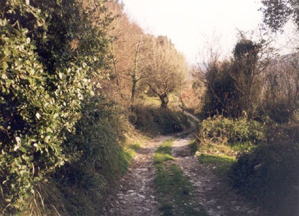
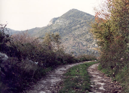
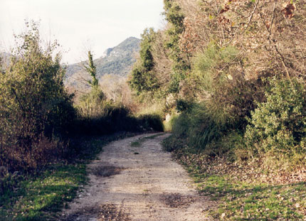
The territory of Trebula bordered on those of Capua, Cales, Teanum, Cubulteria and Caiatia. It had a considerable extent judging by Cicero (Lege Agraria, 2, 66) that thinks the trebulanus ager an area where to buy lots of earth. We can think it coincided about with the bordering four communes of Pontelatone, Castel di Sasso, Formicola and Liberi. The Trebula's territory was linked up with those bordering by branches of the "Via Latina". The ancient "Via Latina" corresponds to present "Via Casilina" linking Rome with Capua. The main branch of the "Via Latina" was that originating from Capua. This branch passed through the "Greci" plain and, at "Santa Maria a Pietro" it forked in two branches: the first led to Prea running along Mount Nizzola towards the East and "Valle dei Morti"; the second, running along the named mount towards the West led to "Corte Rosa", Casalicchio and finally to Trebula (See photos B, C and D).
The economy of Trebula
The economic activity of Trebula based oneself upon the agriculture and the sheep-breeding. The "conciato" cheese named by Marziale (Epigrammi, XIII, 30) and the wine (trebulanum) named by Plinius the Old (Naturalis Historia, 14, 69) and arrived at Trebula in Nero's time, were famous. We must considere the production of pieces of pottery too, because it contributed to the Trebula's wealth. This is testified by the discovery of a late-archaic furnace at the slopes of Mount Castello of Treglia and by the discovery of a roman artisan firm at "Cervarecce" locality at Pontelatone. The Volturno river certainly aided the traffic of the wares from the Trebula's plain to one of the coastal towns. Then the wares were ready to be bound for the Mediterranean's markets.
The excavations of 2007
In 2007, a biennial excavation campaign was carried out with European funds, under the aegis of the Archaeological Superintendency, which has brought to light the largest megalithic door in Europe and a monumental chamber tomb in an exceptional state of conservation. The imposing walls and the majesty of the megalithic gate have earned Trebula the nickname of "Pompeii of the Samnites". Below is a list of youtube channels referring to the aforementioned excavations: